
With at least two more tornadoes touching down in Alberta this week, the total number of tornadoes in the province so far this year rises t0 23 — making it an “exceptionally busy” tornado season, according to Dave Sills, director of the Northern Tornadoes Project, based out of Western University in London, Ont.

Across the three prairie provinces there have been 48 tornadoes so far this year.
“The annual average, based on a 30-year data set, is 34,” said Sills. “So we’re well ahead of the annual average.”
So far this year there have been 23 confirmed tornadoes in Alberta – that’s nearly as many as the previous two years combined.
Global News
The months of June, July and August are the most active period for tornadoes in western Canada.

Despite the tornado that ripped through Dillberry Lake Provincial Park earlier this week, leaving a trail of destroyed camping trailers and cabins, ripped up trees and other damage in its wake, Sills said that so far, Alberta’s tornadoes haven’t been any more severe than normal.
“We’ve had tornado strengths going from the default EF0, so didn’t hit anything, but we assume it’s at least 90 km/h, to an EF2. That’s fairly typical of what we see every year,” Sills added.

“In Manitoba and Saskatchewan there have been two EF3 tornadoes, and that is a bit rare to have two tornadoes that are EF 3 in one season — and we’re only halfway through the season. Hopefully we won’t see more of those. When you get to EF3, you’re talking about houses being destroyed.”
Environment Canada uses the Enhanced Fujita Scale to measure the wind damage from a tornado.

Get breaking National news
Get breaking Canada news delivered to your inbox as it happens so you won’t miss a trending story.
It ranges from an EF0, with a wind speed between 90 and 130 km/h to an EF5 with a wind speed of 315 kilometres or more per hour.
Environment Canada meteorologist, Brian Proctor, told Global News that the reasons why there have been so many tornadoes this year are “a perfect concoction of ingredients.”
“If we think about the kind of spring we’ve had in this early part of summer across the southern part of the prairies, it has been really unsettled, is probably the best way to word it,” Proctor said.
A severe thunderstorm seen near Rollling Hills, Alta. on June 16, 2026 that prompted a tornado warning to be issued.
Courtesy: Chris Ratzlaff
In order for tornadoes to form, Proctor said four things need to happen.
“We need moisture, which we’ve got in abundance this year. We need instability, which we’ve had with the daytime heating across much of the prairies at times. We need wind shear aloft in the atmosphere, which has been really the controlling factor this year more than anything else. And we need a trigger – that could often be a little jet (stream) coming across Alberta, aloft in the atmosphere,” Proctor explained.
“So if we think often what we’ve had for much of this summer so far, we’ve have southeasterly winds at the surface and west to northwest winds a lot. So that rotation of the wind as it goes up in the atmosphere supports rotating supercell thunderstorms. And with rotating super cell thunderstorms, that’s what we need to generate supercell tornadoes. And we’ve (had) that in abundance this year.”
Conversely, while Alberta has had more tornadoes than normal, we’ve also had fewer “big hail events” than normal, said Proctor.
He expects the rest of July to continue to be unsettled, and “potentially problematic.”
“And the other thing to remember in Alberta is our summer season usually starts a little bit later than it does in southern Manitoba and southeastern Saskatchewan and extends a little further into the growing season,” Proctor added.
“So while they’re sort of turning things off by early August, we often don’t turn things off to the middle of August, even maybe a little later.”
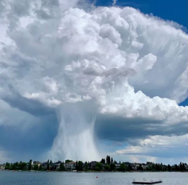
A massive thunderstorm cloud over the southeast Calgary community of Sundance on June 13, 2019.
Courtesy: Jakob Bown
Proctor recommends people who live in tornado country should keep an eye to the sky — look for those big “cauliflower-like” clouds that are indicative of a very strong updraft and are what “typically cause the most dangerous situations.”
“Unless there’s a big change in the weather pattern, which I haven’t really seen in the long-term forecasts, I think we’re going to be expecting more tornadoes,” agrees Sills.
“So people better be tuned in, you know, to the weather and be watching for those Environment Canada alerts, the watches and warnings.”
And if you do hear a warning, take cover.

© 2026 Global News, a division of Corus Entertainment Inc.
